Tropical Storm Fay
000
WTNT41 KNHC 100239
TCDAT1
Tropical Storm Fay Discussion Number 2
NWS National Hurricane Center Miami FL AL062020
1100 PM EDT Thu Jul 09 2020
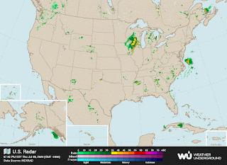
Satellite imagery and surface observations indicate that the
circulation center of Fay is elongated northeast-southwest, with
satellite and radar data showing a strong convective cluster at the
northeastern end of the elongation. There have been no
observations near the center during the past few hours, and the
initial intensity is held at 40 kt based mainly on continuity from
the previous advisory. An Air Force reserve Hurricane Hunter
aircraft is currently enroute to investigate Fay.
Due to the elongated center and the possibility the center is
trying to re-form near the convection, the initial motion is a
somewhat uncertain 010/7. There is no change to the forecast
philosophy from the previous advisory, and essentially no change to
the forecast track. Fay is expected to move generally northward
between a high pressure ridge over the western Atlantic and an
approaching mid-latitude trough for 24-36 h, followed by a turn
toward the north-northeast until dissipation between 60-72 h. The
guidance is in generally good agreement with this scenario, and the
new forecast lies close to the various consensus models.
Fay is currently over the Gulf Stream and within an area of light
to moderate westerly shear caused by an upper-level trough to its
west and southwest. This is producing an environment that should
allow a little strengthening for the next 12-24 h. After that, the
storm should weaken as it passes over cooler waters north of the
Gulf Stream, followed by landfall over the northeastern United
States. The new intensity forecast follows the trend of the
previous forecast in calling for extratropical transition between
48-60 h and dissipation shortly thereafter.
Key Messages:
1. Fay is expected to produce 3 to 5 inches of rain with isolated
totals of 8 inches along and near the track across the mid-Atlantic
states into southeast New York and southern New England. These rains
may result in flash flooding where the heaviest amounts occur.
Widespread river flooding is not expected at this time.
2. Tropical storm conditionsare expected along portions of the
mid-Atlantic and northeast coast Friday and Friday night, and a
Tropical Storm Warning is in effect for the coasts of New Jersey,
New York and Connecticut, including Long Island.
FORECAST POSITIONS AND MAX WINDS
INIT 10/0300Z 36.3N 74.8W 40 KT 45 MPH
12H 10/1200Z 37.7N 74.6W 45 KT 50 MPH
24H 11/0000Z 39.9N 74.1W 45 KT 50 MPH
36H 11/1200Z 43.0N 73.3W 30 KT 35 MPH...INLAND
48H 12/0000Z 46.7N 71.7W 25 KT 30 MPH...INLAND
60H 12/1200Z 50.2N 69.3W 25 KT 30 MPH...POST-TROP/EXTRATROP
72H 13/0000Z...DISSIPATED
$$
Forecaster Beven
000
FXUS61 KCAR 100108
AFDCAR
Area Forecast Discussion
National Weather Service Caribou ME
908 PM EDT Thu Jul 9 2020
.SYNOPSIS...
High pressure will cross the region into Friday. Low pressure
will approach from the south Friday night and track west of the
area Saturday. A cold front will cross the region Sunday
followed by upper level low pressure early next week......
.....SHORT TERM /SATURDAY THROUGH SUNDAY/...
Our focus going into the weekend will be on the track of a
small subtropical low lifting north from the Mid-Atlantic
region. Strong ridging over our area in combination with a weak
but negatively tilted trough in the Ohio Valley is expected to
pull this small system to our west early in the weekend. Friday
night will begin partly cloudy, warm and humid. Clouds will
increase from the south as the subtropical low pulls just west
of western New England. Some light showers, drizzle, and an
increasing south wind are expected later Friday night into
Saturday as the low lifts up to our west. The low will rapidly
track away to the northeast Saturday night into Sunday as
surface low pressure supported by the Midwestern trough, now
lifting up into the northeast, tracks up across the area.
Sunday, otherwise, will be very warm and humid with some
thundershowers possible, especially across the north as slightly
cooler air slides in aloft with the trough lifting across.


0 Comments:
Post a Comment
<< Home