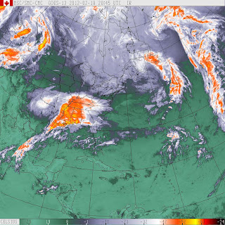
Mid-February Eastern Maritimes & Newfoundland Snowstorm Update One
Gander and vicinity
3:59 PM NST Saturday 18 February 2012
Snowfall warning for
Gander and vicinity upgraded from Winter storm watch
Snowfall amounts between 15 and 20 centimetres are forecast for these regions.
This is a warning that significant snowfall is expected in these regions. Monitor weather conditions..Listen for updated statements.
An intensifying low pressure system just south of Nova Scotia will track northeastward to lie near the Burin Peninsula overnight and over the Northeast Coast by Sunday morning. Snow at times heavy has develop over the southwest coast and will spread across the remainder of the island the overnight. Total snowfall amounts between 15 and 25 centimetres are forecast for regions west of the storms track. This fresh snowfall, combined with strong northeasterly winds gusting up to 70 km/hour, will give reduced visibility in blowing snow, especially in exposed areas.
Strong west to northwesterly winds will develop over the island on Sunday as this low departs out to sea. Flurries and local snow squalls will develop along the west coast of Newfoundland. These snow squalls have the potential to produce reduced visibilities and significant snowfall accumulations over a brief period of time. Motorists are advised to exercise caution as conditions on Sunday will be quite variable and may deteriorate very rapidly.


0 Comments:
Post a Comment
<< Home