Mid-December Rainstorm Update Four


National Weather Service Gray ME
526 PM EST Fri Dec 21 2018
MEC017-NHC003-007-009-220130-
/O.NEW.KGYX.FA.Y.0057.181221T2226Z-181222T0130Z/
/00000.N.RS.000000T0000Z.000000T0000Z.000000T0000Z.OO/
Oxford ME-Coos NH-Grafton NH-Carroll NH-
526 PM EST Fri Dec 21 2018
The National Weather Service in Gray Maine has issued a
* Small Stream Flood Advisory for Poor Drainage Areas for...
Rain and Snowmelt in...
Southwestern Oxford County in western Maine...
Southern Coos County in northern New Hampshire...
Grafton County in northern New Hampshire...
Carroll County in northern New Hampshire...
* Until 830 PM EST.
* At 525 PM EST, NWS Doppler radar indicated persistent rain
continued to fall across northern New Hampshire and northwest
Maine. Another inch or two of rain is expected, and this will
combine with melting snow to cause rises on creeks and streams.
Overflowing poor drainage areas will result in minor flooding in
the advisory area.
* Some locations that will experience flooding include...
Conway, Berlin, Littleton, Lancaster, Fryeburg, Bethel, Bethlehem,
Lincoln, Moultonborough, Rumford, Ossipee, Haverhill, Holderness,
Effingham, Franconia, Andover, Errol, Grafton, Woodstock and
Stratford.
#
This also includes...
Crawford Notch State Park, Franconia Notch, Umbagog Lake State
Park, Kilkenny Ridge Trail, and Mount Moosilauke.
PRECAUTIONARY/PREPAREDNESS ACTIONS...
Be especially cautious at night when it is harder to recognize the
dangers of flooding.
In hilly terrain there are hundreds of low water crossings which are
potentially dangerous in heavy rain. Do not attempt to cross flooded
roads. Find an alternate route.
&&
LAT...LON 4389 7217 4397 7209 4401 7211 4408 7203
4428 7207 4432 7203 4435 7182 4440 7179
4441 7171 4450 7158 4456 7160 4459 7154
4474 7162 4478 7081 4449 7061 4375 7109
4383 7219
$$
Kimble
Flood Watch
National Weather Service Caribou ME
326 PM EST Fri Dec 21 2018
...HEAVY RAIN AND SNOW MELT TONIGHT AND SATURDAY...
.An area of low pressure will bring heavy rainfall to the area
through tonight. The rain will combine with snow melt and may
produce localized flooding of urban and low-lying areas and the
potential for ice jams.
MEZ005-006-220430-
/O.EXA.KCAR.FA.A.0005.000000T0000Z-181223T0000Z/
/00000.0.RS.000000T0000Z.000000T0000Z.000000T0000Z.OO/
Northern Penobscot-Southeast Aroostook-
Including the cities of Millinocket, East Millinocket, Patten,
Medway, Houlton, Hodgdon, Sherman, and Smyrna Mills
326 PM EST Fri Dec 21 2018
...FLOOD WATCH IN EFFECT THROUGH SATURDAY EVENING...
The National Weather Service in Caribou has expanded the
* Flood Watch to include portions of East Central Maine and
Northern Maine, including the following areas, in East Central
Maine, Northern Penobscot. In Northern Maine, Southeast
Aroostook.
* Through Saturday evening
* Rainfall of around 2 inches with locally higher amounts will
fall across the region through Saturday morning. These amounts
could lead to localized flooding of urban and low-lying areas
and significant ponding of water on roads. In addition, warm
temperatures will cause snow melt which combined with the heavy
rain could lead to moving ice in rivers, possibly leading to ice
jams.
PRECAUTIONARY/PREPAREDNESS ACTIONS...
A Flood Watch means there is a potential for flooding based on
current forecasts.
You should monitor later forecasts and be alert for possible
Flood Warnings. Those living in areas prone to flooding should be
prepared to take action should flooding develop.
&&
$$
Coastal Hazard Message
National Weather Service Gray ME
321 PM EST Fri Dec 21 2018
...MINOR COASTAL FLOODING NEAR HIGH TIDE...
.A strong onshore flow has built up water levels in the Gulf of
Maine. With astronomical tides increasing toward their monthly
peak, the added surge in the Gulf of Maine will likely lead to
minor coastal flooding and splashover along the Maine and New
Hampshire coasts around the time of high tide Saturday morning.
MEZ023>028-NHZ014-220830-
/O.NEW.KGYX.CF.Y.0022.181222T1300Z-181222T1700Z/
Coastal York-Coastal Cumberland-Sagadahoc-Lincoln-Knox-
Coastal Waldo-Coastal Rockingham-
321 PM EST Fri Dec 21 2018
...COASTAL FLOOD ADVISORY IN EFFECT FROM 8 AM TO NOON EST
SATURDAY...
The National Weather Service in Gray has issued a Coastal Flood
Advisory, which is in effect from 8 AM to noon EST Saturday.
* TIMING...From 8 AM to noon EST Saturday.
* Impacts...Minor coastal flooding, splash hover, and beach
erosion.
* Location...Coastal New Hampshire and coastal western Maine
including the Midcoast.
* Coastal Flooding...Minor inundation of low lying areas near the
shoreline is possible, along with splash over and beach erosion.
PRECAUTIONARY/PREPAREDNESS ACTIONS...
A Coastal Flood Advisory indicates that onshore winds and tides
will combine to generate flooding of low areas along the shore.
&&
Time of high total tides are approximate to the nearest hour.
FORT POINT NH
MLLW CATEGORIES - MINOR 11.5 FT, MODERATE 12.5 FT, MAJOR 13.5 FT
TOTAL TOTAL DEPARTURE
DAY/TIME TIDE TIDE FROM NORM WAVES FLOOD
FT MLLW FT MHHW FT FT IMPACT
-------- --------- --------- --------- ------- --------
21/10 PM 11.0 1.5 1.9 10.0 NONE
22/10 AM 12.0 2.5 1.4 7.0 MINOR
22/11 PM 9.5 0.0 0.2 5.0 NONE
23/11 AM 11.1 1.6 0.2 3.0 NONE
24/12 AM 9.7 0.2 0.2 2.0 NONE
24/12 PM 11.6 2.1 0.6 1.0 MINOR
HAMPTON HARBOR NH
MLLW CATEGORIES - MINOR 11.0 FT, MODERATE 12.0 FT, MAJOR 13.0 FT
TOTAL TOTAL DEPARTURE
DAY/TIME TIDE TIDE FROM NORM WAVES FLOOD
FT MLLW FT MHHW FT FT IMPACT
-------- --------- --------- --------- ------- --------
21/10 PM 10.6 1.1 1.9 8.0 NONE
22/10 AM 11.5 2.0 1.4 6.0 MINOR
22/11 PM 9.1 -0.4 0.2 5.0 NONE
23/11 AM 10.7 1.2 0.2 2.0 NONE
24/12 AM 9.3 -0.2 0.2 1.0 NONE
24/12 PM 11.2 1.7 0.6 1.0 MINOR
PORTLAND ME
MLLW CATEGORIES - MINOR 12.0 FT, MODERATE 13.0 FT, MAJOR 14.0 FT
TOTAL TOTAL DEPARTURE
DAY/TIME TIDE TIDE FROM NORM WAVES FLOOD
FT MLLW FT MHHW FT FT IMPACT
-------- --------- --------- --------- ------- --------
21/10 PM 11.1 1.4 1.9 10.0 NONE
22/10 AM 12.6 2.9 1.8 8.0 MINOR
22/11 PM 9.7 -0.0 0.2 6.0 NONE
23/11 AM 11.3 1.6 0.2 3.0 NONE
24/12 AM 9.9 0.2 0.2 2.0 NONE
24/12 PM 11.8 2.1 0.6 1.0 NONE
&&
$$
3:43 PM AST Friday 21 December 2018
Rainfall warning in effect for:
Guysborough County
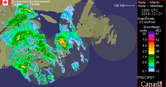
Rain, heavy at times is expected. The frozen ground has a reduced ability to absorb this rainfall.
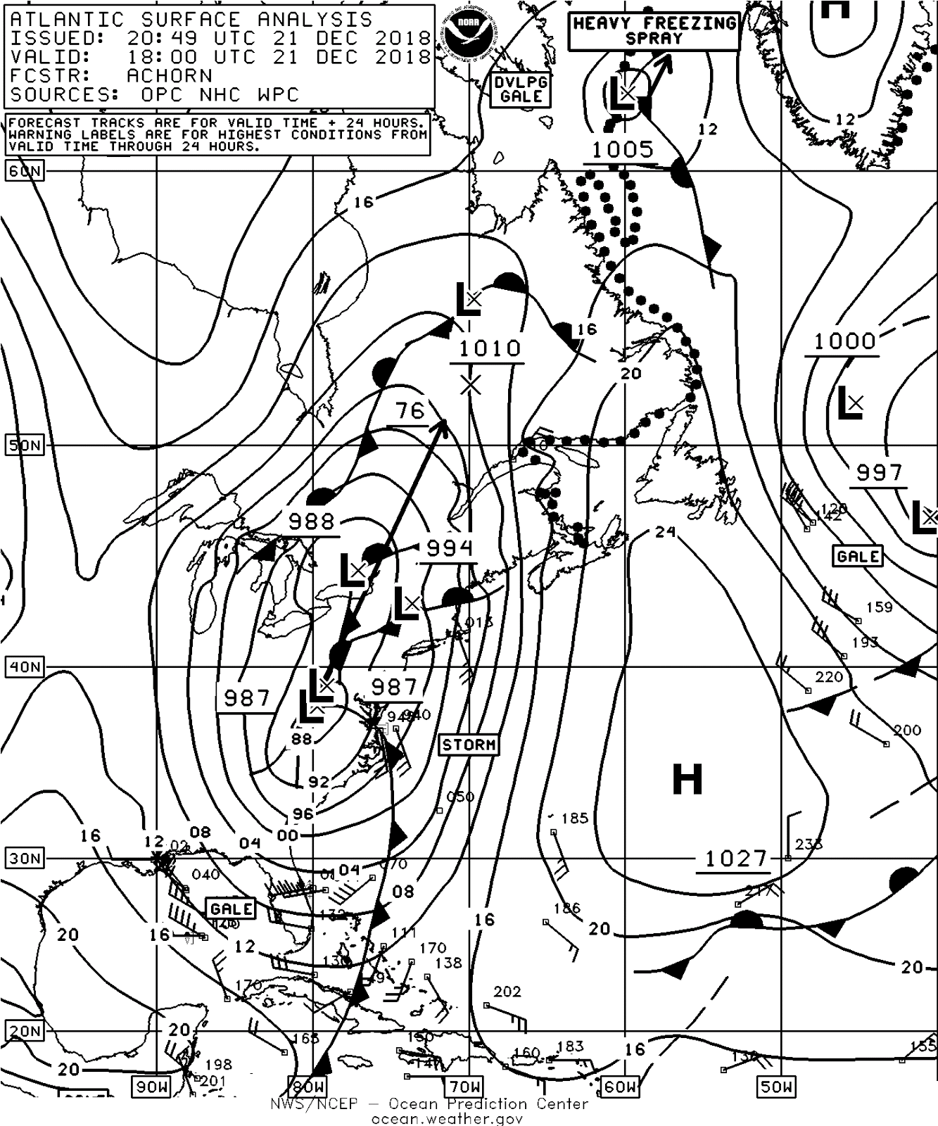
A developing low pressure system over the northeastern United States is forecast to track northward to pass west of the Maritimes tonight and Saturday. Light rain over southwestern Nova Scotia will become heavy at times tonight, then taper to a few showers late in the day Saturday. Total rainfall amounts of 25 to 40 mm are expected with this system with possible higher amounts in areas of heaviest rain.
Strong southerly winds accompanying the system will bring unseasonably warm temperatures to the region tonight and Saturday, with daytime highs expected to reach into the double digits on Saturday. The rain and melting snow may cause minor flooding in some areas. Cool northwesterly winds behind the system will quickly drop temperatures to below freezing overnight into Sunday.
In addition, large waves and higher than normal water levels are likely along parts of the Atlantic coast on Saturday.
Localized flooding in low-lying areas is possible. Heavy downpours can cause flash floods and water pooling on roads.
Rainfall warnings are issued when significant rainfall is expected.
Please continue to monitor alerts and forecasts issued by Environment Canada. To report severe weather, send an email to NSstorm@canada.ca or tweet reports using #NSStorm.
3:42 PM AST Friday 21 December 2018
Rainfall warning in effect for:
Mount Carleton - Renous Highway
Rain, heavy at times is expected. The frozen ground has a reduced ability to absorb this rainfall.
A developing low pressure system over the northeastern United States is forecast to track northward to pass west of the Maritimes tonight before moving into Quebec on Saturday.
Rain and strengthening southerly winds will persist tonight for New Brunswick prior to tapering on Saturday. Rainfall is expected to intensify tonight, and near 35 mm of rain is forecast for central and northwestern New Brunswick by Saturday afternoon. Higher amounts approaching 60 mm are expected in southwestern New Brunswick.
As the heaviest rains move in to the region, southerly wind gusts up to 80 km/h are expected, especially over exposed coastal areas and over the higher terrain of southern New Brunswick tonight and into early Saturday morning.
Additionally, the southerly winds will bring unseasonably warm temperatures to the province tonight and Saturday, with daytime highs expected to reach the mid teens for parts of New Brunswick on Saturday. The rain and melting snow may cause minor flooding in some areas. Cool northwesterly winds behind the system will quickly drop temperatures to below freezing by Sunday morning.
Furthermore, higher than normal water levels are possible along parts of the Bay of Chaleur coast and the Acadian Peninsula at high tide Saturday afternoon.
Localized flooding in low-lying areas is possible. Heavy downpours can cause flash floods and water pooling on roads.
Rainfall warnings are issued when significant rainfall is expected.
Please continue to monitor alerts and forecasts issued by Environment Canada. To report severe weather, send an email to NBstorm@canada.ca or tweet reports using #NBStorm.
posted by Advackia at 3:24 PM
![]()
![]()

0 Comments:
Post a Comment
<< Home