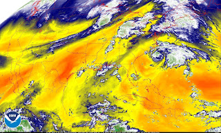
Late September Rainstorm with a possible Subtropical Connection
10:51 AM ADT Tuesday 25 September 2018
Special weather statement in effect for:
Fredericton and Southern York County
Potential for significant rainfall.
A low pressure system approaching from the Great Lakes will bring rain to New Brunswick tonight through Wednesday, ending Thursday morning. There is a chance rainfall amounts could reach warning levels (50 mm in 24 hours), mainly for southern New Brunswick, with a lesser risk for western areas.
At this time due to variations in the system's expected track and intensity, uncertainty remains regarding detailed rainfall amounts and the areas most likely to be impacted.
Please continue to monitor ECCC forecasts as warnings may be required.
Please continue to monitor alerts and forecasts issued by Environment Canada. To report severe weather, send an email to NBstorm@canada.ca or tweet reports using #NBStorm.
10:51 AM ADT Tuesday 25 September 2018
Special weather statement in effect for:
Halifax Metro and Halifax County West
Potential for significant rainfall.
A low pressure system approaching from the Great Lakes will bring rain to Nova Scotia overnight tonight through Wednesday, ending by Thursday afternoon. There is a chance rainfall amounts could reach or exceed warning levels (50 mm in 24 hours), mainly for western mainland Nova Scotia and areas along the mainland's Atlantic Coast.
At this time due to variations in the system's expected track and intensity, uncertainty remain regarding detailed rainfall amounts and the areas most likely to be impacted.
Please continue to monitor ECCC forecasts as warnings may be required.
Please continue to monitor alerts and forecasts issued by Environment Canada. To report severe weather, send an email to NSstorm@canada.ca or tweet reports using #NSStorm.
ZCZC MIATWOAT ALL
TTAA00 KNHC DDHHMM
Tropical Weather Outlook
NWS National Hurricane Center Miami FL
200 PM EDT Tue Sep 25 2018
For the North Atlantic...Caribbean Sea and the Gulf of Mexico:
The National Hurricane Center has issued the final advisory on
Post-Tropical Cyclone Leslie, located a little more than 1000 miles
west-southwest of the Azores.
1. A broad area of low pressure located about 200 miles south of Cape
Hatteras, North Carolina, continues to produce disorganized showers
and a few thunderstorms. Satellite and surface data indicate that
the circulation of the low remains elongated and not well defined.
However, this system could still become a tropical depression this
afternoon or tonight while it moves slowly northwestward to
northward. By Wednesday, additional development appears unlikely
due to strong upper-level winds while the system moves northward and
north-northeastward near the eastern United States coast. An Air
Force Reserve reconnaissance aircraft is scheduled to investigate
the system later this afternoon. Regardless of development, this
system is likely to bring scattered showers and thunderstorms across
portions of northeastern South Carolina and eastern North Carolina
this afternoon and tonight. In addition, dangerous surf conditions
and rip currents are expected along portions of the North Carolina
coast today. For more information, please see products from your
local National Weather Service office.
* Formation chance through 48 hours...medium...50 percent.
* Formation chance through 5 days...medium...50 percent.....
....Forecaster Pasch


0 Comments:
Post a Comment
<< Home