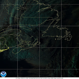
Extratropical Storm Teddy (Gale Force) Moves Into The Gulf Of St. Lawrence
001
WTNT35 KNHC 232037
TCPAT5
BULLETIN
Post-Tropical Cyclone Teddy Advisory Number 46
NWS National Hurricane Center Miami FL AL202020
500 PM AST Wed Sep 23 2020
...TEDDY MOVING JUST WEST OF NEWFOUNDLAND...
...STILL LIKELY TO PRODUCE DANGEROUS WAVES AND STRONG WINDS ACROSS
SOUTHWESTERN NEWFOUNDLAND...
SUMMARY OF 500 PM AST...2100 UTC...INFORMATION
----------------------------------------------
LOCATION...48.6N 59.6W
ABOUT 70 MI...115 KM NNW OF PORT AUX BASQUES NEWFOUNDLAND
MAXIMUM SUSTAINED WINDS...50 MPH...85 KM/H
PRESENT MOVEMENT...NNE OR 30 DEGREES AT 31 MPH...50 KM/H
MINIMUM CENTRAL PRESSURE...975 MB...28.80 INCHES
WATCHES AND WARNINGS
--------------------
CHANGES WITH THIS ADVISORY:
None
SUMMARY OF WATCHES AND WARNINGS IN EFFECT:
A Tropical Storm Warning is in effect for...
* Port aux Basques to Francois Newfoundland
A Tropical Storm Warning means that tropical storm conditions are
expected within the warning area.
For storm information specific to your area, please monitor
products issued by your national meteorological service.
DISCUSSION AND OUTLOOK
----------------------
At 500 PM AST (2100 UTC), the center of Post-Tropical Cyclone Teddy
was located near latitude 48.6 North, longitude 59.6 West. The
post-tropical cyclone is moving toward the north-northeast near 31
mph (50 km/h), and this general motion is expected to continue
through Thursday. On the forecast track, the center of Teddy will
move closer to northwestern Newfoundland tonight and into the
Labrador Sea on Thursday before becoming absorbed by a larger
non-tropical low.
Maximum sustained winds are near 50 mph (85 km/h) with higher gusts.
Little change in strength is forecast before the system dissipates
on Thursday.
Tropical-storm-force winds extend outward up to 205 miles (335 km)
from the center.
The estimated minimum central pressure is 975 mb (28.80 inches).
HAZARDS AFFECTING LAND
----------------------
Key messages for Teddy can be found in the Tropical Cyclone
Discussion under AWIPS header MIATCDAT5 and WMO header WTNT45 KNHC
and on the web at www.hurricanes.gov/text/MIATCDAT5.shtml.
SURF: Large swells generated by Teddy are affecting Bermuda, the
Lesser Antilles, the Greater Antilles, the Bahamas, the east coast
of the United States, and Atlantic Canada. These swells are likely
to cause life-threatening surf and rip current conditions. Please
consult products from your local weather office.
WIND: Tropical storm conditions are expected to continue in the
warning area for the next several hours.
NEXT ADVISORY
-------------
Next intermediate advisory at 800 PM AST.
Next complete advisory at 1100 PM AST.
$$
Forecaster Blake


0 Comments:
Post a Comment
<< Home