Wednesday, April 19, 2006


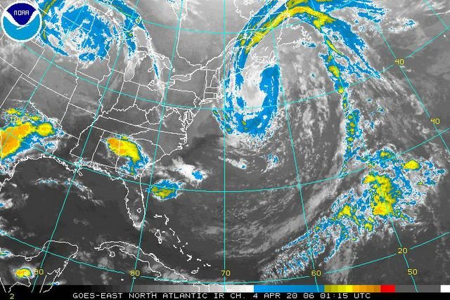
Beautiful Color Enhanced IR Satellite image of the intense storm located South of Nova Scotia. Image was taken this evening. Note the tightly coiled coma shaped center. Posted by Picasa

Visible Satellite Images taken earlier this afternoon. It shows the same storm center located South of Nova Scotia. Besides our high winds, the low pressure zone is also brought heavy rain, high winds, large waves, and this morning even snow, to Nova Scotia, Newfoundland Island, PEI and SE New Brunswick. Posted by Picasa

Surface chart depicting the storm center south of Nova Scotia, that is causing our high gradient generated winds in conjuncture with a High Pressure area located to our West. Posted by Picasa

Weather Report For Johnson Settlement NB, Recorded At 2100 UCT On 04/19/2006

Temp: Current; 15 C/59 F, High; 16.2 C/61 F, Low; (to current time) 5 C/41 F


Hum: 17%


Bar: 1000 mb/29.53 Inches; Holding Steady


Sky: Mainly Cloudy; Cirrostratus


Wind: North; 16 gusting to 22 mph/26 gusting to 35 km/h


Precip: None


Total Precip: None


Note: Frequent gusts of 40 mph/64 km/h, occurred in the Predawn and Afternoon hours, with a lull in the Morning hours. Several brief peak gusts of 60 mph/97 km/h, occurred late this afternoon.

Humidity of 16% recorded at 5:15 PM Local Time (ADT); this is the lowest of the month, thus far.

Yesterday Highlights

Note: Brief peak gusts of 30 mph/48 km/h, occurred in the evening. One brief peak gust to 40 mph/64 km/h, occurred late in the evening.