Monday, May 15, 2006

Weather Report For Johnson Settlement NB, Recorded At 2100 UCT On 05/15/2006

Temp: Current; 21.9 C/71 F, High; 23.4 C/74 F, Low; 2.4 C/36 F


Hum: 24% (lowset of the month, thus far)


Bar: 1017 mb/30.03 Inches; Falling Rapidly


Sky: Mainly Sunny; Cirrus and Cirrostratus


Wind: East; 5 gusting to 15 mph/8 gusting to 24 km/h


Precip: None


Total Precip: None


Note: Brief peak wind gusts of 30 mph/48 km/h, occurred this afternoon.

Color Enhanced Water Vapor Satellite image, showing the moist onshore (SE) Flow still entrenched over Southern New England, between a low to the West and a blocking ridge to the East. This flow has persisted for three days, and should not shift away to the NE for another 24 hr. Posted by Picasa

Doppler Radar rainfall estimate for the last 24 hr over New England. Posted by Picasa

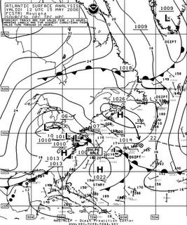
Surface Chart depicting the onshore (SE) flow between a complex low centered over the Great Lakes, and a blocking ridge of high pressure centered south of Nova Scotia. This synoptic setup caused three days of continues heavy rain over parts of Southern New England, causing the worst flooding in many places since 1936. Posted by Picasa

News Stories About The Near Record Flooding in Sourhern New England

Weather Summary For 05/14/2006

Temp: High; 21.9 C/71 F, Low; 3.2 C/38 F


Total Precip: None


Note: Barometeric Pressure reading of 1026 mb/30.32 Inches, recorded at 9:30 AM Local Time (ADT). This is the highest recorded in May, thus far.

Brief peak wind gusts of 30 mph/48 km/h, occurred in the early afternoon.

Weather Summary For 05/13/2006

Temp: High; 22 C/72 F, Low; 2.4 C/36 F


Total Precip: None


Note: Barometeric Pressure reading of 1026 mb/30.31 Inches, recorded at 7:30 AM Local Time (ADT). This is the highest recorded in May, thus far.

Brief peak wind gusts of 30 mph/48 km/h, occurred in the afternoon.