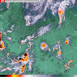
Meteorological Autumn Storm
FXUS61 KCAR 290124
AFDCAR
Area Forecast Discussion
National Weather Service Caribou ME
924 PM EDT Mon Aug 28 2023
.SYNOPSIS...
High pressure will exit across the Maritimes overnight. A cold
front approaches Tuesday night, then crosses the region
Wednesday. High pressure then builds in and lasts through
Saturday.....
......SHORT TERM /TUESDAY NIGHT THROUGH THURSDAY/...
There are a few features at play through the middle of the week
that will dictate the weather pattern across northern and
eastern Maine. There exist two tropical systems at the moment,
one being Hurricane Franklin which is currently moving north
well off the SE CONUS coast, and Tropical Storm Idalia which is
entering the southern Gulf of Mexico. Neither storm will
directly impact our forecast area. This is due to an upper level
longwave trough moving across northern New England through
mid-week, which will scoop up these systems and escort them out
into the middle of the Atlantic Ocean. That said, these tropical
systems will contribute to our weather in other ways. One of
which will be in the form of rip currents and increased swell
and wave heights from Hurricane Franklin, and more can be read
about this in the Tides/Coastal Flooding section below. The
other impact will be the increase in atmospheric moisture
available to the area.
As the longwave trough interacts with these tropical systems,
mid-level moisture will be pulled northwards into northern New
England. This increase in moisture will result in another
wetting rain day, especially across the Downeast region where
steady rain in excess of one to two inches of total rainfall are
expected. Though Downeast will likely see the highest rainfall
totals, northern areas will likely see around a half inch or
more of rainfall through the day on Wednesday.
Behind the trough of low pressure, high pressure will begin to
build into the area on Thursday. This high pressure will set up
a drier pattern for the area......
8:09 PM ADT Monday 28 August 2023
Rain at times heavy is forecast Tuesday night and Wednesday.
Total rainfall: 40 to 90 mm, with higher amounts possible.
Locations: Atlantic coast and eastern Nova Scotia.
Time span: Tuesday overnight into Thursday morning.
Potential impacts: Similar storms in the past have caused road shoulder erosion and washouts as well as elevated river levels. Winds are not expected to be impactful from this weather system over land.
Remarks: Heavy rain is possible, again. There remains a fair bit of uncertainty with regards to how this weather disturbance, which is unrelated to Hurricane Franklin, may interact with the hurricane as it is expected to pass well south of the province. As this information becomes clearer, timing and locations of the heaviest rain as well as expected rainfall amounts may change. Rainfall warnings may be required.
Please continue to monitor alerts and forecasts issued by Environment Canada. To report severe weather, send an email to NSstorm@ec.gc.ca or tweet reports using #NSStorm.
2:52 PM ADT Monday 28 August 2023
Tropical Cyclone Information Statement (Franklin) in effect for:
Marine Zone
Maritime Waters
Laurentian Fan
Newfoundland Waters
Southeastern Grand Banks
Southwestern Grand Banks
Hurricane Franklin as of Monday afternoon was situated midway between the Bahamas and Bermuda and has intensified considerably to category 4 intensity. It may briefly reach category-5 while tracking well west then northwest of Bermuda.
Latest computer models predict Franklin to move along or just inside the Canadian marine forecast district near category-2 or strong-category-1 intensity late Thursday into Friday. Interests in the Southern Grand Banks should pay close attention to forecasts especially now that the storm has reached the upper categories of intensity. It will take some time for the intensity to drop down before reaching the edge of the region.
There is a possibility that some moisture from the hurricane could feed into an elongated low pressure system well to the north of it over Atlantic Canada beginning later Wednesday. The details of this are not yet well understood but we will provide more discussion in later bulletins if required. This bulletin is only valid for Laurentian Fan and the Southern Grand Banks so consult public forecast products issued by the Atlantic Storm Prediction Centre and the Newfoundland and Labrador Weather Office for details concerning rainfall.
Large ocean swells will travel far north away from the hurricane and bring heavy surf conditions to parts of the Atlantic coast of Nova Scotia and southern Newfoundland beginning Wednesday. Indications are that swells near 2m (7 feet) will approach the shore on Thursday and could break up to 3m (10 feet).
After our assessments this morning, we have decided to commence with 6-hourly bulletins and track forecasts at 3 pm ADT Tuesday.
Forecaster: Fogarty
Please continue to monitor alerts issued by the Canadian Hurricane Centre and forecasts issued by Environment Canada.
Hazardous Weather Outlook
National Weather Service Caribou ME
334 AM EDT Mon Aug 28 2023
MEZ011-015>017-029-030-032-290745-
Central Penobscot-Southern Penobscot-Interior Hancock-
Central Washington-Coastal Hancock-Coastal Washington-
Northern Washington-
334 AM EDT Mon Aug 28 2023
This Hazardous Weather Outlook is for Coastal DownEast Maine, Far
Eastern Maine, Interior DownEast Maine and Penobscot Valley Maine.
.DAY ONE...Today and tonight.
Hazardous weather is not expected at this time.
.DAYS TWO THROUGH SEVEN...Tuesday through Sunday.
Persistent south to southeast long period swells from Hurricane
Franklin Wednesday through Thursday will result in dangerous rip
currents and could also result in high surf and splashover along the
Downeast coast. Franklin is expected to track over 600 miles south
and east of eastern Maine in the open Atlantic Ocean.
Heavy rain is possible Wednesday with the approaching cold front and
tropical moisture from Franklin. Isolated flooding in urban areas
and small streams is possible especially across the Downeast into the
Greater Bangor area.
.SPOTTER INFORMATION STATEMENT...
Weather spotters are encouraged to report significant weather
conditions according to Standard Operating Procedures.
$$


