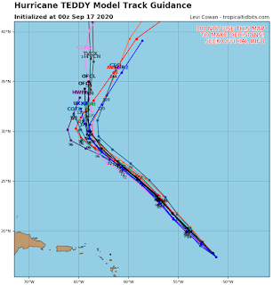
Hurricane Teddy (Category One) Could Pose A Long-Range Threat To The Region
000
WTNT35 KNHC 170243
TCPAT5
BULLETIN
Hurricane Teddy Advisory Number 19
NWS National Hurricane Center Miami FL AL202020
1100 PM AST Wed Sep 16 2020
...TEDDY FORECAST TO STRENGTHEN OVER THE NEXT COUPLE OF DAYS...
SUMMARY OF 1100 PM AST...0300 UTC...INFORMATION
-----------------------------------------------
LOCATION...17.8N 51.5W
ABOUT 670 MI...1075 KM ENE OF THE LESSER ANTILLES
MAXIMUM SUSTAINED WINDS...90 MPH...150 KM/H
PRESENT MOVEMENT...NW OR 315 DEGREES AT 13 MPH...20 KM/H
MINIMUM CENTRAL PRESSURE...976 MB...28.82 INCHES
WATCHES AND WARNINGS
--------------------
There are no coastal watches or warnings in effect.
DISCUSSION AND OUTLOOK
----------------------
At 1100 PM AST (0300 UTC), the center of Hurricane Teddy was located
near latitude 17.8 North, longitude 51.5 West. Teddy is moving
toward the northwest near 13 mph (20 km/h), and this general motion
is expected to continue through the weekend.
Maximum sustained winds are near 90 mph (150 km/h) with higher
gusts. Strengthening is forecast during the next couple of days,
and Teddy could become a major hurricane Thursday night or Friday.
Hurricane-force winds extend outward up to 35 miles (55 km) from the
center and tropical-storm-force winds extend outward up to 255 miles
(405 km).
The estimated minimum central pressure is 976 mb (28.82 inches).
HAZARDS AFFECTING LAND
----------------------
SURF: Large swells generated by Teddy are reaching the Lesser
Antilles and the northeastern coast of South America and should
spread westward to the Greater Antilles, the Bahamas, Bermuda, and
the east coast of the United States by the weekend. These
swells are likely to cause life-threatening surf and rip current
conditions. Please consult products from your local weather office.
NEXT ADVISORY
-------------
Next complete advisory at 500 AM AST.
$$
Forecaster Berg
ZCZC MIATCDAT5 ALL
TTAA00 KNHC DDHHMM
Hurricane Teddy Discussion Number 19
NWS National Hurricane Center Miami FL AL202020
1100 PM AST Wed Sep 16 2020
Teddy has been a perplexing hurricane thus far. The infrared
satellite presentation appears rather impressive, with the center
embedded beneath a Central Dense Overcast with cloud tops as cold
as -85 degrees Celsius. Despite the presentation, however, Dvorak
estimates from TAFB and SAB are a consensus T4.5/77 kt, and
objective estimates range between 70-75 kt. Teddy's initial
intensity is therefore set just above these estimates at 80 kt.
A recent ASCAT pass indicated that Teddy's center is a little
farther to the southwest than previously estimated. However, the
long-term motion remains toward the northwest (315/11 kt). The
track forecast remains straightforward the the next 3 days, with
the guidance in good agreement that a mid-tropospheric high over
the central Atlantic will drive the hurricane northwestward toward
the western Atlantic. There is a little more spread among the
track models on days 4 and 5, related to timing differences on
exactly where and how fast Teddy begins to recurve ahead of an
approaching mid-latitude trough coming from the northeastern United
States. The new NHC track forecast has been nudged westward during
the first 3 days to account for the initial position adjustment,
but otherwise it's still close to the previous prediction even with
the increasing model spread on days 4 and 5.
An upper-level trough situated to the northwest of Teddy is causing
about 10-15 kt of deep-layer southwesterly shear over the
hurricane, and some model analyses suggest that there could be
stronger shear in a layer below the level of the upper-level
outflow. The deep-layer shear is expected to increase a bit during
the next day or so, but this should be offset by a favorable
thermodynamic environment, allowing for some intensification during
that time. The shear might relax by days 3 and 4, but then the
thermodynamic environment becomes a little less conducive for
strengthening. In particular, Teddy may move over the cold wake
of Hurricane Paulette, and the SHIPS guidance indicates that
relatively warm upper-level temperatures could be a negative
factor. All that said, the NHC intensity forecast lies near the
top end of the guidance envelope, showing Teddy peaking in
intensity in a couple of days and then only gradually weakening
through the end of the forecast period.
FORECAST POSITIONS AND MAX WINDS
INIT 17/0300Z 17.8N 51.5W 80 KT 90 MPH
12H 17/1200Z 18.9N 52.6W 85 KT 100 MPH
24H 18/0000Z 20.3N 54.1W 95 KT 110 MPH
36H 18/1200Z 21.8N 55.6W 100 KT 115 MPH
48H 19/0000Z 23.5N 57.1W 100 KT 115 MPH
60H 19/1200Z 25.3N 59.1W 95 KT 110 MPH
72H 20/0000Z 27.0N 61.1W 95 KT 110 MPH
96H 21/0000Z 30.0N 64.0W 90 KT 105 MPH
120H 22/0000Z 35.0N 64.0W 90 KT 105 MPH
$$
Forecaster Berg


