Coastal Hazard Message
National Weather Service Gray ME
346 AM EST Mon Nov 26 2018
...Minor coastal flooding and splashover today through Tuesday...
MEZ023-024-NHZ014-262100-
/O.NEW.KGYX.CF.Y.0019.181126T1600Z-181126T2100Z/
Coastal York-Coastal Cumberland-Coastal Rockingham-
346 AM EST Mon Nov 26 2018
...COASTAL FLOOD ADVISORY IN EFFECT FROM 11 AM THIS MORNING TO
4 PM EST THIS AFTERNOON...
The National Weather Service in Gray has issued a Coastal Flood
Advisory, which is in effect from 11 AM this morning to 4 PM EST
this afternoon.
* Location...The southern Maine coast southward to the New
Hampshire Seacoast.
* Coastal Flooding...High astronomical tides and an increasing
onshore wind will allow for tidal departures to 1 to 2 feet
today. This will likely result in minor coastal flooding and
splashover around the time of this afternoon`s high tide.
PRECAUTIONARY/PREPAREDNESS ACTIONS...
A Coastal Flood Advisory indicates that onshore winds and tides
will combine to generate flooding of low areas along the shore.
&&
Time of high total tides are approximate to the nearest hour.
FORT POINT NH
MLLW CATEGORIES - MINOR 11.5 FT, MODERATE 12.5 FT, MAJOR 13.5 FT
TOTAL TOTAL DEPARTURE
DAY/TIME TIDE TIDE FROM NORM WAVES FLOOD
FT MLLW FT MHHW FT FT IMPACT
-------- --------- --------- --------- ------- --------
26/01 PM 12.4 2.9 1.4 5.0 MINOR
27/02 AM 12.0 2.5 2.8 15.0 MINOR
27/02 PM 11.9 2.4 1.6 9.0 MINOR
28/02 AM 10.5 1.0 1.5 4.0 NONE
28/03 PM 11.0 1.5 1.0 3.0 NONE
29/04 AM 9.7 0.2 0.7 3.0 NONE
29/04 PM 10.3 0.8 0.7 2.0 NONE
HAMPTON HARBOR NH
MLLW CATEGORIES - MINOR 11.0 FT, MODERATE 12.0 FT, MAJOR 13.0 FT
TOTAL TOTAL DEPARTURE
DAY/TIME TIDE TIDE FROM NORM WAVES FLOOD
FT MLLW FT MHHW FT FT IMPACT
-------- --------- --------- --------- ------- --------
26/01 PM 11.8 2.5 1.4 4.0 MINOR
27/02 AM 11.7 2.2 2.8 14.0 MINOR
27/02 PM 11.5 2.0 1.5 9.0 MINOR
28/03 AM 10.2 0.7 1.5 4.0 NONE
28/03 PM 10.7 1.2 1.0 3.0 NONE
29/04 AM 9.4 -0.1 0.7 3.0 NONE
29/04 PM 10.0 0.5 0.7 2.0 NONE
PORTLAND ME
MLLW CATEGORIES - MINOR 12.0 FT, MODERATE 13.0 FT, MAJOR 14.0 FT
TOTAL TOTAL DEPARTURE
DAY/TIME TIDE TIDE FROM NORM WAVES FLOOD
FT MLLW FT MHHW FT FT IMPACT
-------- --------- --------- --------- ------- --------
26/01 PM 12.6 2.9 1.4 4.0 MINOR
27/02 AM 11.8 2.1 2.4 12.0 NONE
27/02 PM 12.3 2.6 1.7 9.0 MINOR
28/02 AM 10.7 1.0 1.5 4.0 NONE
28/03 PM 11.2 1.5 1.0 2.0 NONE
29/04 AM 9.8 0.1 0.6 2.0 NONE
29/04 PM 10.5 0.8 0.6 2.0 NONE
&&
$$
URGENT - WINTER WEATHER MESSAGE
National Weather Service Caribou ME
1031 AM EST Mon Nov 26 2018
MEZ001-003>005-010-031-270000-
/O.CON.KCAR.WS.W.0016.181127T0600Z-181128T0600Z/
Northwest Aroostook-Northern Somerset-Northern Piscataquis-
Northern Penobscot-Central Piscataquis-Southern Piscataquis-
Including the cities of Allagash, Clayton Lake, Madawaska,
Fort Kent, Frenchville, Baker Lake, Billy-Jack Depot,
Baxter St Park, Chamberlain Lake, Churchill Dam, Mount Katahdin,
Millinocket, East Millinocket, Patten, Medway, Greenville,
Monson, Blanchard, Dover-Foxcroft, Milo, and Guilford
1031 AM EST Mon Nov 26 2018
...WINTER STORM WARNING REMAINS IN EFFECT FROM 1 AM TUESDAY TO
1 AM EST WEDNESDAY...
* WHAT...Heavy snow expected. Total snow accumulations of 8 to 11
inches are expected. Locally greater accumulations across higher
terrain areas.
* WHERE...Northwest Aroostook, Northern Somerset, Northern
Piscataquis, Northern Penobscot, Central Piscataquis and
Southern Piscataquis Counties.
* WHEN...From 1 AM Tuesday to 1 AM EST Wednesday.
* ADDITIONAL DETAILS...Plan on difficult travel conditions,
including during the morning commute on Tuesday. Expect
significant reductions in visibility at times.
PRECAUTIONARY/PREPAREDNESS ACTIONS...
A Winter Storm Warning for snow means severe winter weather
conditions will make travel very hazardous. If you must travel,
keep an extra flashlight, food and water in your vehicle in case
of an emergency. The latest road conditions for Maine can be
obtained by going to newengland511.org.
&&
$$
URGENT - WINTER WEATHER MESSAGE
National Weather Service Caribou ME
1031 AM EST Mon Nov 26 2018
MEZ002-006-011-015-032-270000-
/O.CON.KCAR.WS.A.0012.181127T0600Z-181128T0600Z/
Northeast Aroostook-Southeast Aroostook-Central Penobscot-
Southern Penobscot-Northern Washington-
Including the cities of Presque Isle, Caribou, Van Buren,
Mars Hill, Houlton, Hodgdon, Sherman, Smyrna Mills, Lincoln,
Howland, Springfield, Bangor, Brewer, Orono, Old Town, Danforth,
Vanceboro, and Topsfield
1031 AM EST Mon Nov 26 2018
...WINTER STORM WATCH REMAINS IN EFFECT FROM LATE TONIGHT THROUGH
LATE TUESDAY NIGHT...
* WHAT...Heavy snow possible. Total snow accumulations of 3 to 7
inches, with localized amounts of 9 to 11 inches west of Route
11 and Interstate 95, are possible.
* WHERE...Northeast Aroostook, Southeast Aroostook, Central
Penobscot, Southern Penobscot and Northern Washington Counties.
* WHEN...From late tonight through late Tuesday night.
* ADDITIONAL DETAILS...Plan on difficult travel conditions,
including during the morning commute on Tuesday. Significant
reductions in visibility are possible.
PRECAUTIONARY/PREPAREDNESS ACTIONS...
A Winter Storm Watch means there is potential for significant
snow, sleet or ice accumulations that may impact travel. Continue
to monitor the latest forecasts.
&&
$$
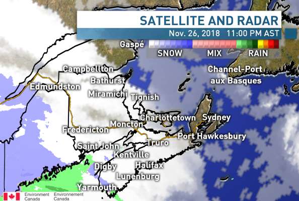
Norcross
11:04 AM AST Monday 26 November 2018
Special weather statement in effect for:
Queens County P.E.I.
Messy weather and strong winds expected mid-week.
A pair of low pressure systems will bring rain, snow and wind to Prince Edward Island Tuesday night and again Wednesday night and Thursday. The first low will give rain or snow and strong easterly
winds across Prince Edward Island Tuesday night. Rain or snow will end or taper to showers or flurries by Wednesday morning.
Precipitation is forecast to redevelop late Wednesday or Wednesday night as the second low pressure system approaches. This low is forecast to intensify and give strong northeasterly winds, rain and/or
snow to the province on Wednesday night and Thursday. Warnings may be issued for wind, rain or snow. in addition, strong northeasterly winds will likely produce large waves and heavy pounding surf
along north-facing coastlines Wednesday night and Thursday.
There is still some uncertainty as to the timing and strength of the second weather system. Meteorologists at Environment and Climate Change Canada will monitor the development of these systems and
provide further information as it becomes available.
Please continue to monitor alerts and forecasts issued by Environment Canada. To report severe weather, send an email to PEstorm@canada.ca or tweet reports using #PEStorm.
11:03 AM AST Monday 26 November 2018
Special weather statement in effect for:
Halifax Metro and Halifax County West
Messy weather and strong winds expected mid-week.
A pair of low pressure systems will bring rain, snow and wind to Nova Scotia on Tuesday and again Wednesday night and Thursday. The first low will give rain and strong easterly winds across Nova Scotia
on Tuesday, with snow likely over some northern portions of the province. Rain and snow will end or taper to showers or flurries by Wednesday morning.
Precipitation is forecast to redevelop late Wednesday or Wednesday night as the second low pressure system approaches. This low is forecast to intensify and give strong northeasterly winds, rain and/or
snow to the province Wednesday night and Thursday. Warnings may be issued for wind, rain or snow. In addition, strong northeasterly winds will likely cause large waves and pounding surf along north-
facing coastlines of the Gulf of St. Lawrence and Cabot Strait on Wednesday night and Thursday.
There is still some uncertainty as to the timing and strength of the second weather system. Meteorologists at Environment and Climate Change Canada will monitor the development of these systems and
provide further information as it becomes available.
Please continue to monitor alerts and forecasts issued by Environment Canada. To report severe weather, send an email to NSstorm@canada.ca or tweet reports using #NSStorm.
10:42 AM AST Monday 26 November 2018
Special weather statement in effect for:
Moncton and Southeast New Brunswick
An extended period of messy weather expected for mid-week.
A pair of low pressure systems approaching the Maritimes will bring a mix of snow and rain to New Brunswick, beginning early Tuesday and continuing into Thursday. On Tuesday, significant snowfall is
forecast over portions of central New Brunswick where a snowfall warning has been issued. Snowfall warnings may be extended northward as the snow is expected to persist over northern areas Tuesday
night.
Precipitation is expected to taper to showers or flurries on Wednesday as the first low weakens.
Precipitation is expected to increase in intensity again on Wednesday night as the second low approaches. Many localities will likely receive additional snowfall. In addition, strong northeasterly winds are
likely to develop over eastern New Brunswick on Thursday associated with the second low, then diminish on Thursday night as it moves off. Large waves and heavy pounding surf are likely on Thursday
where northeasterly winds blow onshore from the Gulf of St. Lawrence.
There is still some uncertainty as to the timing and strength of the second weather system. Meteorologists at Environment and Climate Change Canada will monitor the development of these systems and
provide further information as it becomes available.
Please continue to monitor alerts and forecasts issued by Environment Canada. To report severe weather, send an email to NBstorm@canada.ca or tweet reports using #NBStorm.
10:39 AM AST Monday 26 November 2018
Snowfall warning in effect for:
Fredericton and Southern York County
Snowfall with total amounts of 15 to 20 cm is expected.
A low pressure system approaching from the southwest will spread snow and rain across New Brunswick on Tuesday. Over portions of central New Brunswick, snow giving up to 15 centimetres of
accumulation is forecast. Highest amounts will likely be over higher terrain where temperatures will be slightly colder.
Be prepared to adjust your driving with changing road conditions. Surfaces such as highways, roads, walkways and parking lots may become difficult to navigate due to accumulating snow.
Snowfall warnings are issued when significant snowfall is expected.
Please continue to monitor alerts and forecasts issued by Environment Canada. To report severe weather, send an email to NBstorm@canada.ca or tweet reports using #NBStorm.