Wednesday, June 28, 2006


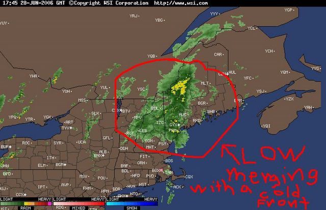
Doppler Radar Composite, showing the precipitation of the now frontal low dissipating as it moves through our area. Resulting in only two bands of very light showers. Posted by Picasa

Surface chat depicting the now merged frontal low moving towards the NE, and weakening. Posted by Picasa

Today Highlights

Total Precip: a trace of rain, fell in the evening


Note: Frequent wind gusts of 30 mph/48 km/h, with a few peak brief gusts to 40 mph/64 km/h, occurred this evening.

The Former Tropical Low merges with the Cold Front

000
ABNT20 KNHC 282111
TWOAT
TROPICAL WEATHER OUTLOOK
NWS TPC/NATIONAL HURRICANE CENTER MIAMI FL
530 PM EDT WED JUN 28 2006

FOR THE NORTH ATLANTIC...CARIBBEAN SEA AND THE GULF OF MEXICO...

THE LOW PRESSURE AREA THAT PRODUCED LOCALLY HEAVY RAINS AND STRONG
GUSTY WINDS ACROSS PORTIONS OF NEW ENGLAND TODAY HAS MERGED WITH A
FRONTAL SYSTEM AND IS MOVING OVER THE CANADIAN MARITIME PROVINCES.

Weather Report For Johnson Settlement NB, Recorded At 2100 UCT On 06/28/2006

Temp: Current; 24.1 C/75 F, High; 27.3 C/81 F, Low; 14 C/57 F


Hum: 60%


Bar: 1019 mb/30.09 Inches; Falling Slowly


Sky: Overcaste; Cirrocumulus and Cumulus


Wind: SW; 8 gusting to 14 mph/13 gusting to 23 km/h


Precip: None


Total Precip: (to current time) None


Note: Frequent wind gusts of 30 mph/48 km/h, with a few peak brief gusts to 40 mph/64 km/h, occurred this morning and afternoon.

Surface chart depicting the former tropical low merging with a cold front over Western New England. Posted by Picasa

Doppler Radar Composite, showing the former tropical low now merging with a cold front over Western New England. This feature is continuing to rapidly move NNE at between 20 and 25 mph, as it drops brief, but heavy rainfall over said area. Posted by Picasa

Yesterday Highlights

Note: Frequent wind gusts of 30 mph/48 km/h occurred early in the evening.